Table of Contents
Remote Sensing Satellite Constellations
Earth Observation
http://www.phiphase.com/satellite_coverage.htm A general talk about radar and antenna FOV, and some simple geometric analysis. Descriptions may not be 100% correct but very clear and pictorial. For example, some excerpts:
- Off-Nadir Pointing Field of View Geometry
- The FoV now projected onto the Earth’s surface is an ellipse rather than a circle as is the case for the Nadir-pointing beam. Such a FoV may be referred to as a Swath, a term usually reserved for Earth Observation sensors e.g. SAR.
Classification

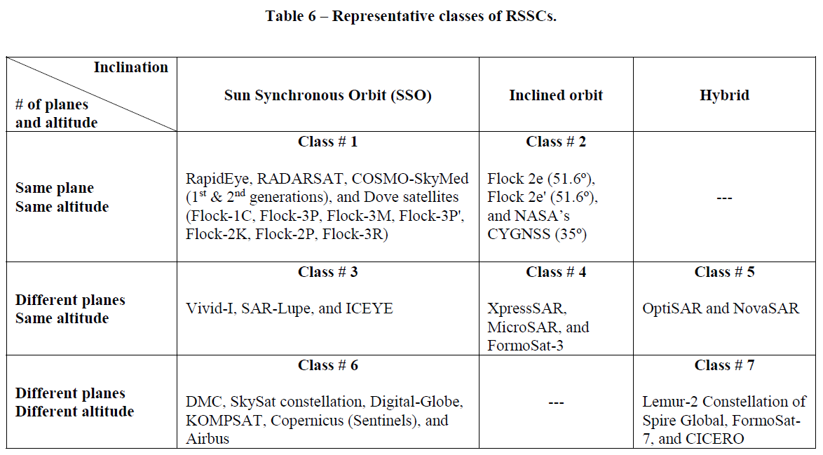
Sanad et cl. have gave a detailed summary of remote sensing satellite constellations [1].
Multiple orbits
ICEYE (Aalto University and ESA)
3 satellites x 6 SSOs
X-band SAR
OptiSAR
SSO 10:30am, 450km.
Mid-Inclination Orbit (MIO) ~45º, 450km.
Eight tandem pairs: one X-band and L-band SAR instrument ahead; trailing optical satellite $\approx2$mins behind.
Using onboard processing, it is capable to detect, clasify objects of interest, and then automatically task the optical satellite to take a high-resolution image or video of the selected objects. [1]
DigitalGlobe (Maxar)
WorldVide-Legion is next generation.
2 go to SSOs; 4 go to 45° MIO orbits.
Flock (Platnet Labs)
SkySat (Platnet Labs)
a constellation of sub-meter resolution Earth observation satellites owned by Planet Labs, providing imagery, high-definition video and analytics services
https://directory.eoportal.org/web/eoportal/satellite-missions/s/skysat
Sun-synchronous near-circular orbit, altitude = 600 km, inclination = 97.8º, LTDN (Local Time on Descending Node) = 10:30 hours.
Orbit: Sun-synchronous orbit, altitude = 515 km, inclination = 97.56º.
Orbit: Sun-synchronous orbit, altitude = 695 km, inclination = 98.3º.
Orbit: Sun-synchronous near-circular orbit, altitude of ~500 km, inclination of ~97º.
Orbit: Sun-synchronous circular orbit with an altitude of 575 km, inclination of ~98º, LTDN (Local Time of Descending Node) of 10:30 hours.
Single orbit
Pléiades
same phased orbit and are offset at 180° to offer a daily revisit capability over any point on the globe.
The Pléiades also share the same orbital plane as the SPOT 6 and 7, forming a larger constellation with 4 satellites, 90° apart from one another.
SSO, 695 km
Agility for Responsive Tasking
Optimized daily acquisition capacity (taking into account genuine order book, weather constraints, conflicts…) reaching 300,000 km2 per day and per satellite.
查任务规划方法
Uplink Stations
The Pléiades tasking plan are refreshed and uploaded three times per day, allowing for last minute requests and the ability to utilize up-to-the-minute weather forecasts.
https://eoportal.org/web/eoportal/satellite-missions/p/pleiades
Direct Tasking principles
Earth-i
https://earthi.space/constellations/
DMC3/TripleSat Constellation
KOMPSAT series of satellites
SuperView Constellation
The Vivid-i Constellation
A-train (satellite constellation)
https://en.wikipedia.org/wiki/A-train_(satellite_constellation)
| SSO | 705 km |
| Inclination | 98.14 deg |
| crosses the equator | each day at ~1:30 pm solar time |
| again on the night side | ~1:30 am |
OCO-2 (NASA) + GCOM-W1 (JAXA) + Aqua (NASA) + AUra (NASA)
C-train
CloudSat (NASA) + CALIPSO (CNES + NASA)
(retired) RapidEye (Planet Labs)
https://en.wikipedia.org/wiki/RapidEye
RapidEye (1998–2012) → RapidEye Blackbridge (2012→2013) → Blackbridge (2013–2014) → Planet Labs acquired and then retired RapidEye (202004xx)
SSO, 630 km, Equator Crossing Time: 11:00 am local time (approximately)\ Global Revisit Time: Daily (off-nadir) / 5.5 days (at nadir)\ Swath Width: 77 km

